Showing posts with label PAGASA. Show all posts

Typhoon Songda (Bagyong Chedeng) Update May 27, 2011 | PAGASA Weather Forecast

Typhoon Songda (Bagyong Chedeng) PAGASA Update


Typhoon Songda's Satellite Shot as of 5 p.m. on May 27, 2011

Bagyong Chedeng "has maintained its strength as it continues to threaten Batanes area", the latest PAGASA bulletin reads.

Check out the said Typhoon Chedeng update below:

Severe Weather Bulletin No. 18
Tropical Cyclone Warning: Typhoon "CHEDENG" (SONGDA)
Issued at 5:00 p.m., Friday, 27 May 2011

Typhoon "CHEDENG" has maintained its strength as it continues to threaten Batanes area.
Location of Center:
(as of 4:00 p.m.)
160 km Southeast of Basco, Batanes
Coordinates: 19.5°N,123.3°E
Strength: Maximum sustained winds of 195 kph near the center and gustiness of up to 230 kph
Movement: North Northwest at 19 kph
Forecast Positions/Outlook: Saturday afternoon:
400 km Northeast of Basco, Batanes
Sunday afternoon:
820 km Northeast of Basco, Batanes or
110 km East Southeast of Okinawa, Japan


Areas having Public Storm Warning Signal

Signal Number 3

Batanes Group of Islands

Signal Number 2


Babuyan Group of Island

Signal Number 1

Apayao
Cagayan
Isabela


Public Storm Warning Signals elsewhere are now lowered.

Residents in low lying and mountainous areas under signals #3, #2 and #1 are alerted against possible flashfloods and landslides. Likewise, those living in coastal areas are alerted against big waves or storm surges generated by this tropical cyclone.

Typhoon “Chedeng” is expected to enhance the southwest monsoon and will bring rains over Southern Luzon, Visayas and Mindanao including Metro Manila.

Bagyong Chedeng Update from PAGASA - May 26, 2011

Bagyong Chedeng Update - May 26

Bagyong Chedeng's 5 p.m. Satellite Shot

Bagyong Chedeng "has slightly intensified as it continues to move northwestward", PAGASA's latest Typhoon Chedeng bulletin reads.

Check out below the said PAGASA update on Tropical Storm Chedeng:

***Bagyong Chedeng May 27, 2011 Update:

http://noypistuff.blogspot.com/2011/05/bagyong-chedeng-update-may-27-2011.html


Severe Weather Bulletin No. 14
Tropical Cyclone Warning: Typhoon "CHEDENG" (SONGDA)
Issued at 5:00 p.m., Thursday 26 May 2011

Typhoon "CHEDENG" has slightly intensified as it continues to move northwestward.

Location of Center:
(as of 10:00 a.m.)
260 km North Northeast of Virac, Catanduanes or at 300 km East Southeast of Casiguran, Aurora
Coordinates: 15.8°N,125.4°E
Strength: Maximum sustained winds of 175 kph near the center and gustiness of up to 210 kph
Movement: Northwest at 19 kph
Forecast Positions/Outlook: Friday afternoon:
320 km North Northeast of Casiguran, Aurora or at 200 km East Northeast of Aparri, Cagayan
Saturday afternoon:
590 km Northeast of Basco, Batanes or 190 km Southwest of Okinawa, Japan

Areas having Public Storm Warning Signal

Signal Number 1

Catanduanes, Camarines Sur, Camarines Norte, Albay, Quirino, Aurora, Quezon provinces, Polilo Island, Isabela and Cagayan

Advisory

Residents in low lying and mountainous areas under #1 are alerted against possible flashfloods and landslides. Likewise, those living in coastal areas are alerted against big waves or storm surges generated by this tropical cyclone.

Typhoon “Chedeng” is expected to enhance the southwest monsoon and will bring rains over Visayas and Mindanao.

Bagyong Chedeng PAGASA Update | May 25, 2011

A new bulletin has been posted by the PAGASA. For the May 27, 2011 Bagyong Chedeng update, please head to:

http://noypistuff.blogspot.com/2011/05/bagyong-chedeng-update-may-27-2011.html

Bagyong Chedeng May 25, 2011 PAGASA Update


Bagyong Chedeng 6 p.m. satellite image | Source PAGASA

PAGASA (Philippine Atmospheric Geophysical and Astronomical Services Administration), the Philippine weather bureau, has released its latest bulletin on Tropical Storm Chedeng saying that the weather disturbance has sustained its strength and has increased its rate of movement.

The agency now has 6 provinces on its list of areas having Public Storm Warning Signal (PSWS) Number 2 and listed 9 areas with PSWS Number 1.

Check the latest bulletin below:

Severe Weather Bulletin No. 10
Tropical Cyclone Warning: Typhoon "CHEDENG" (SONGDA)
Issued at 5:00 p.m., Wednesday 25 May 2011

Typhoon "CHEDENG" has accelerated as it maintained its strength.

Location of Center (as of 10:00 a.m.): 310 km East of Catarman, Northern Samar

Coordinates: 12.8°N, 127.7°E

Strength: Maximum sustained winds of 130 kph near the center and gustiness of up to 160 kph

Movement: Northwest at 15 kph

Forecast Positions/Outlook:

Thursday afternoon:
230 km North of Catarman, Northern Samar or
at 140 km Northeast of Virac, Catanduanes
Friday afternoon:
150 km North Northeast of Baler, Aurora by Friday afternoon
Saturday afternoon:
470 km North of Baler, Aurora or
at 40 km West of Basco, Batanes

Areas Having Public Storm Warning Signal

Signal Number 2 (Winds of 61-100 kph is expected in at least 24 hrs)

Catanduanes
Sorsogon
Albay
Camarines Sur
Camarines Norte
Samar provinces

Signal Number 1 (Winds of 45-60 kph is expected within the next 36 hours)

Marinduque
Masbate
Burias
Ticao Islands
Quezon
Polilio Island
Aurora

PAGASA : 'Tropical Storm Chedeng slightly accelerated' | Latest Weather Forecast

PAGASA (Philippine Atmospheric Geophysical and Astronomical Services Administration), the Philippines' weather agency, has released its last bulletin on Typhoon "Chedeng" (international name: "Songda") for the day.


PAGASA's May 24, 2011 11 p.m. satellite shot of Tropical Storm Chedeng

The weather bureau said Tropical Storm Chedeng has slightly accelerated its movement as it is heading in a West Northwest direction.

Public Storm Warning Signal (PSWS) Number 2 has also been raised by the PAGASA in Catanduanes and PSWS Number 1 in Sorsogon, Burias island, Ticao island, Albay, Camarines Sur, Camarines Norte ans Samar provinces.

Check out below the latest PAGASA Bulletin:

Bagyong Chedeng May 27, 2011 Update:

http://noypistuff.blogspot.com/2011/05/bagyong-chedeng-update-may-27-2011.html


***Bayong Chedeng Update, May 26, 2011 at 5 a.m.

http://noypistuff.blogspot.com/2011/05/bagyong-chedeng-may-26-2011-update-from.html

***Bagyong Chedeng Update, May 25, 2011 at 5 a.m.


Severe Weather Bulletin Number SEVEN
Tropical Cyclone Warning: Tropical Storm "CHEDENG" (SONGDA)

Issued at 11:00 p.m., Tuesday, 24 May 2011

Tropical Storm "CHEDENG" has slightly accelerated as it continuously moves West Northwestward.

Location of Center (as of 10:00 p.m.): 420 km East of Catarman, Northen Samar

Coordinates: 12.5°N, 128.9°E

Strength: Maximum sustained winds of 115 kph near the center and gustiness of up to 145 kph
Movement: West Northwest at 17 kph

Forecast Positions/Outlook:

Wednesday evening:
150 km North of Virac, Catanduanes
Thursday evening:
in the vicinity of Isabela, Cagayan
Friday evening:
80 km West of Basco, Batanes

Areas Having Public Storm Warning Signal

Signal No. 2 (60-100 kph winds)

Catanduanes

Signal No. 1 (45-60 kph winds)

Sorsogon
Burias island
Ticao island
Albay
Camarines Sur
Camarines Norte
Samar Provinces

Advisory

Residents in low lying and mountainous areas under signals #2 & #1 are alerted against possible flashfloods and landslides. Likewise, those living in coastal areas are alerted against big waves or storm surges generated by this tropical cyclone.

TS "Chedeng" is expected to enhance the southwest monsoon and will bring rains over Visayas and Mindanao.

The public and the disaster coordinating councils concerned are advised to take appropriate actions and watch for the next bulletin to be issued at 5 a.m. tomorrow.

Tropical Storm Chedeng could bring heavy rains like Ondoy - PAGASA

Tropical Storm Chedeng could bring heavy rains like Tropical Storm Ondoy according to weather experts as reported by ABS-CBN News.

Bagyong Ondoy (international name: Ketsana) is a tropical storm that hit Manila and other parts of Luzon in 2009 which caused floods and landslides, killing 468 people.

According to an ABS-CBN report, the Philippine Atmospheric Geophysical and Astronomical Services Administration (PAGASA) said Typhoon Chedeng could yield the same amount of rain as Ondoy in a rate of 20-55 millimeters per hour.

The weather bureau however added that the Tropical Storm will be missing Manila as it is heading to Northern Luzon where it would it would make it landfall which was predicted to be on Wednesday night.

Meanwhile here's the latest Bagyong Chedeng update from PAGASA:

Bagyong Chedeng May 27, 2011 Update:

http://noypistuff.blogspot.com/2011/05/bagyong-chedeng-update-may-27-2011.html


***Bagyong Chedeng Update, May 26, 2011 at 5 a.m.

http://noypistuff.blogspot.com/2011/05/bagyong-chedeng-may-26-2011-update-from.html

***Bagyong Chedeng Update, May 25, 2011 at 5 a.m.


***Bagyong Chedeng Update, May 24, 2011 at 11:00 p.m


Severe Weather Bulletin Number FIVE
Tropical Cyclone Warning: Tropical Storm "CHEDENG" (SONGDA)
Issued at 11:00 a.m., Tuesday, 24 May 2011

Tropical Storm "CHEDENG" has slowed down as it moves in a West Northwest direction.

Location of Center (as of 10:00 a.m.): 490 km East of Borongan, Eastern Samar

Coordinates: 12.1°N, 130.5°E

Strength: Maximum sustained winds of 105 kph near the center and gustiness of up to 135 kph

Movement: West Northwest at 13 kph

Forecast Positions/Outlook:

Wednesday morning:
390 km East Southeast of Virac, Catanduanes
Thursday morning:
180 km Northeast of Virac, Catanduanes or
360 km Southeast Casiguran, Aurora
Friday morning:
130 km Northeast of Casiguran, Aurora or
220 km Southeast of Aparri, Cagayan

Areas Having Public Storm Warning Signal

Signal No. 1 (30-60 kph winds)

Catanduanes
Camarines Sur
Albay
Sorsogon
Samar Provinces

Residents living in low lying and mountainous areas under signal # 1 are alerted against possible flashfloods and landslides.

TS "Chedeng" is expected to enhance the southwest monsoon and will bring rains over Visayas and Mindanao.

The public and the disaster coordinating councils concerned are advised to take appropriate actions and to watch for the next bulletin to be issued at 11 PM today.

PAGASA Update on Tropical Storm Chedeng | May 24, 2011

PAGASA has just released its latest bulletin on Bagyong Chedeng. PAGASA said Typhoon Chedeng has slowed down as it heads West Northwestward.


PAGASA's satellite shot of Bagyong Chedeng at 11 a.m. on May 24, 2011


Here's the latest PAGASA update on Tropical Storm Chedeng:

Bagyong Chedeng May 27, 2011 Update:

http://noypistuff.blogspot.com/2011/05/bagyong-chedeng-update-may-27-2011.html


***Bayong Chedeng Update, May 26, 2011 at 5 a.m.

http://noypistuff.blogspot.com/2011/05/bagyong-chedeng-may-26-2011-update-from.html

***Bagyong Chedeng Update, May 25, 2011 at 5 a.m.


***Bagyong Chedeng Update, May 24, 2011 at 11:00 p.m


Severe Weather Bulletin Number FIVE Tropical Cyclone Warning: Tropical Storm "CHEDENG" (SONGDA)
Issued at 11:00 a.m., Tuesday, 24 May 2011

Tropical Storm "CHEDENG" has slowed down as it moves in a West Northwest direction.

Location of Center (as of 10:00 a.m.): 490 km East of Borongan, Eastern Samar

Coordinates: 12.1°N, 130.5°E

Strength: Maximum sustained winds of 105 kph near the center and gustiness of up to 135 kph

Movement: West Northwest at 13 kph

Forecast Positions/Outlook:

Wednesday morning:
390 km East Southeast of Virac, Catanduanes
Thursday morning:
180 km Northeast of Virac, Catanduanes or
360 km Southeast Casiguran, Aurora
Friday morning:
130 km Northeast of Casiguran, Aurora or
220 km Southeast of Aparri, Cagayan

Areas Having Public Storm Warning Signal

Signal No. 1 (30-60 kph winds)

Catanduanes
Camarines Sur
Albay
Sorsogon
Samar Provinces

Residents living in low lying and mountainous areas under signal # 1 are alerted against possible flashfloods and landslides.

TS "Chedeng" is expected to enhance the southwest monsoon and will bring rains over Visayas and Mindanao.

The public and the disaster coordinating councils concerned are advised to take appropriate actions and to watch for the next bulletin to be issued at 11 PM today.

Bagyong Chedeng predicted to make a landfall on Wednesday night | PAGASA Weather Forecast

Bagyong Chedeng, which has continued its strength and moving West Northwestward, has been predicted to make a landfall on Wednesday night by the Philippine Atmospheric Geophysical and Astronomical Services Administration (PAGASA), ABS-CBN reports.

As of 8 a.m. on May 24, here's PAGASA's illustration of the track made by Bagyong Chedeng and its 72-hour predicted route:


Meanwhile, the weather bureau has issued its latest Tropical Storm bulletin. Here's what it contains:

Bagyong Chedeng May 27, 2011 Update:

http://noypistuff.blogspot.com/2011/05/bagyong-chedeng-update-may-27-2011.html


***Bagyong Chedeng Update, May 26, 2011 at 5 a.m.

http://noypistuff.blogspot.com/2011/05/bagyong-chedeng-may-26-2011-update-from.html

***Bagyong Chedeng Update, May 25, 2011 at 5 a.m.


***Bagyong Chedeng Update, May 24, 2011 at 11:00 p.m


Severe Weather Bulletin Number FIVE Tropical Cyclone Warning: Tropical Storm "CHEDENG" (SONGDA)
Issued at 11:00 a.m., Tuesday, 24 May 2011

Tropical Storm "CHEDENG" has slowed down as it moves in a West Northwest direction.

Location of Center (as of 10:00 a.m.): 490 km East of Borongan, Eastern Samar

Coordinates: 12.1°N, 130.5°E

Strength: Maximum sustained winds of 105 kph near the center and gustiness of up to 135 kph

Movement: West Northwest at 13 kph

Forecast Positions/Outlook:

Wednesday morning:
390 km East Southeast of Virac, Catanduanes
Thursday morning:
180 km Northeast of Virac, Catanduanes or
360 km Southeast Casiguran, Aurora
Friday morning:
130 km Northeast of Casiguran, Aurora or
220 km Southeast of Aparri, Cagayan

Areas Having Public Storm Warning Signal

Signal No. 1 (30-60 kph winds)

Catanduanes
Camarines Sur
Albay
Sorsogon
Samar Provinces

Residents living in low lying and mountainous areas under signal # 1 are alerted against possible flashfloods and landslides.

TS "Chedeng" is expected to enhance the southwest monsoon and will bring rains over Visayas and Mindanao.

The public and the disaster coordinating councils concerned are advised to take appropriate actions and to watch for the next bulletin to be issued at 11 PM today.

Bagyong Chedeng May 24, 2011 PAGASA Update

Bagyong Chedeng has entered the Philippines. PAGASA said Bagyong Chedeng is accelerating slightly as it continues to move in a West Northwest direction.

As of 2 a.m. on May 24, here's PAGASA's illustration of the track made by Bagyong Chedeng and its 72-hour predicted route:


Meanwhile, the weather bureau has issued its latest Tropical Storm bulletin. Here's what it contains:

Bagyong Chedeng May 27, 2011 Update:

http://noypistuff.blogspot.com/2011/05/bagyong-chedeng-update-may-27-2011.html

***Bagyong Chedeng Update, May 26, 2011 at 5 a.m.

http://noypistuff.blogspot.com/2011/05/bagyong-chedeng-may-26-2011-update-from.html


***Bagyong Chedeng Update, May 25, 2011 at 5 a.m.


***Bagyong Chedeng Update, May 24, 2011 at 11:00 p.m

Severe Weather Bulletin Number FIVE
Tropical Cyclone Warning: Tropical Storm "CHEDENG" (SONGDA)
Issued at 11:00 a.m., Tuesday, 24 May 2011

Tropical Storm "CHEDENG" has slowed down as it moves in a West Northwest direction.

Location of Center (as of 10:00 a.m.): 490 km East of Borongan, Eastern Samar

Coordinates: 12.1°N, 130.5°E

Strength: Maximum sustained winds of 105 kph near the center and gustiness of up to 135 kph

Movement: West Northwest at 13 kph

Forecast Positions/Outlook:

Wednesday morning:
390 km East Southeast of Virac, Catanduanes
Thursday morning:
180 km Northeast of Virac, Catanduanes or
360 km Southeast Casiguran, Aurora
Friday morning:
130 km Northeast of Casiguran, Aurora or
220 km Southeast of Aparri, Cagayan

Areas Having Public Storm Warning Signal

Signal No. 1 (30-60 kph winds)

Catanduanes
Camarines Sur
Albay
Sorsogon
Samar Provinces

Residents living in low lying and mountainous areas under signal # 1 are alerted against possible flashfloods and landslides.

TS "Chedeng" is expected to enhance the southwest monsoon and will bring rains over Visayas and Mindanao.

The public and the disaster coordinating councils concerned are advised to take appropriate actions and to watch for the next bulletin to be issued at 11 PM today.

Weather Update of PAGASA on Typhoon 'Chedeng' as of 11 a.m. (May 23)

Bagyong Chedeng May 27, 2011 Update:

http://noypistuff.blogspot.com/2011/05/bagyong-chedeng-update-may-27-2011.html


May 26, 2011 5 am update is now available. Please head to:

http://noypistuff.blogspot.com/2011/05/bagyong-chedeng-may-26-2011-update-from.html

***Bagyong Chedeng Update, May 25, 2011 at 5 a.m.


***Bagyong Chedeng Update, May 24, 2011 at 11:00 p.m


***Bagyong Chedeng Update from PAGASA, May 23, 2011 at 11:00 a.m.


Severe Weather Bulletin Number TWO

Tropical Cyclone Alert: Tropical Storm "CHEDENG" (SONGDA)
Issued at 11:00 a.m., Monday, 23 May 2011

Location of Center (as of 10:00 a.m.): 795 kms East of Guiuan, Eastern Samar

Coordinates: 11.2°N, 133.8°E

Strength: Maximum sustained winds of 95 kph near the center and gustiness of up to 120 kph

Movement: West Northwest at 15 kph

Forecast Positions/Outlook: Tuesday morning: 540 kms East Northeast of Guiuan, Eastern Samar; Wednesday morning: 360 km East Northeast of Virac, Catanduanes; Thursday morning: 265 km North Northeast of Virac, Cantanduanes or 250 km East of Casiguran, Aurora

No Public Storm Warning Signals Raised

This weather disturbance is expected not to directly affect any part of the country within the next 24 hrs.

The public and the disaster coordinating councils concerned are advised to take appropriate actions and watch for the next bulletin to be issued at 11 PM today.


***Weather Update from PAGASA: May 23, 2011, 5 a.m.

Severe Weather Bulletin Number ONE
Tropical Cyclone Alert: Severe Tropical Storm "CHEDENG" (SONGDA)
Issued at 5:00 a.m., Monday, 23 May 2011


The tropical storm East of Northern Mindanao has entered the Philippine Area of Responsibility (PAR) and was named "CHEDENG".

Location of Center(as of 4:00 a.m.): 880 kms East of Guiuan, Eastern Samar

Coordinates: 10.5°N, 134.7°E

Strength: Maximum sustained winds of 95 kph near the center and gustiness of up to 120 kph

Movement: West Northwest at 13 kph

Forecast Positions/Outlook: Tuesday morning:620 kms East of Guiuan, Eastern Samar;
Wednesday morning: 390 km East Northeast of Guiuan, Eastern Samar or
510 km East Southeast of Virac, Catanduanes; Thursday morning: 240 km East Northeast of Virac, Cantanduanes

No Public Storm Warning Signals Raised

This weather disturbance is expected not to directly affect any part of the country within the next 24 hrs.

The public and the disaster coordinating councils concerned are advised to take appropriate actions and watch for the next bulletin to be issued at 11 AM today.


***Weather Update from PAGASA: May 22, 2011, 5 p.m.

The weather update from PAGASA posted at 5:00 p.m. on May 22 says that Typhoon "Chedeng" which has an international name of "Songda" is now 20 kilometers nearer to Northern Mindanao since the last update at 10:00 a.m. It is now estimated to be 1,050 kilometers away from east of Region X.

A 1:00 a.m., May 23, 2011 satellite shot of Bagyong Chedeng | Source: PAGASA

The weather disturbance has a maximum sustained winds of 85 kph near the center and gustiness of up to 100 kph. It is forecast to enter the Philippine area of responsibility Sunday night or Monday morning as it is moving at a rate of 11 kph.

PAGASA previously reported that Bagyong Chedeng will be affecting the Bicol Region.

Here's the said advisory from PAGASA:

At 4:00 p.m. today, Tropical Storm (SONGDA) estimated based on satellite and surface data at 1,050 km East of Northern Mindanao,(10.0°N, 136.2°E) with maximum sustained winds of 85 kph near the center and gustiness of up to 100 kph. It is forecast to move West Northwest at 11 kph.

Weather Update: 'Bagyong Chedeng' enters the Philippine Area of Responsibility

Bagyong Chedeng May 27, 2011 Update:

http://noypistuff.blogspot.com/2011/05/bagyong-chedeng-update-may-27-2011.html

Bagyong Chedeng May 26, 2011 5 a.m. Update:

http://noypistuff.blogspot.com/2011/05/bagyong-chedeng-may-26-2011-update-from.html

***Bagyong Chedeng Update, May 25, 2011 at 5 a.m.


***Bagyong Chedeng Update, May 24, 2011 at 11:00 p.m


***Bagyong Chedeng Update, May 24, 2011 at 11:00am


Severe Weather Bulletin Number FIVE

Tropical Cyclone Warning: Tropical Storm "CHEDENG" (SONGDA)
Issued at 11:00 a.m., Tuesday, 24 May 2011

Tropical Storm "CHEDENG" has slowed down as it moves in a West Northwest direction.

Location of Center (as of 10:00 a.m.): 490 km East of Borongan, Eastern Samar

Coordinates: 12.1°N, 130.5°E

Strength: Maximum sustained winds of 105 kph near the center and gustiness of up to 135 kph

Movement: West Northwest at 13 kph

Forecast Positions/Outlook:

Wednesday morning:
390 km East Southeast of Virac, Catanduanes
Thursday morning:
180 km Northeast of Virac, Catanduanes or
360 km Southeast Casiguran, Aurora
Friday morning:
130 km Northeast of Casiguran, Aurora or
220 km Southeast of Aparri, Cagayan

Areas Having Public Storm Warning Signal

Signal No. 1 (30-60 kph winds)

Catanduanes
Camarines Sur
Albay
Sorsogon
Samar Provinces

Residents living in low lying and mountainous areas under signal # 1 are alerted against possible flashfloods and landslides.

TS "Chedeng" is expected to enhance the southwest monsoon and will bring rains over Visayas and Mindanao.

The public and the disaster coordinating councils concerned are advised to take appropriate actions and to watch for the next bulletin to be issued at 11 PM today.

***Bagyong Chedeng Update from PAGASA May 24, 2011, 5 a.m.

As of 2 a.m. on May 24, here's PAGASA's illustration of the track made by Bagyong Chedeng and its 72-hour predicted route:


Meanwhile, the weather bureau has issued its latest Tropical Storm bulletin. Here's what it contains:

Severe Weather Bulletin Number FOUR Tropical Cyclone Warning: Tropical Storm "CHEDENG" (SONGDA)
Issued at 5:00 a.m., Tuesday, 24 May 2011

Tropical Storm "CHEDENG" has intensified as it moved westward.

Location of Center (as of 4:00 a.m.): 540 km East of Borongan, Eastern Samar

Coordinates: 11.9°N, 130.8°E

Strength: Maximum sustained winds of 105 kph near the center and gustiness of up to 135 kph

Forecast Positions/Outlook:

Wednesday morning:
330 km East of Virac, Catanduanes
Thursday morning:
210 km East Southeast of Casiguran, Aurora
Thursday morning:
70 km North of Aparri, Cagayan

Areas Having Public Storm Warning Signal

Signal No. 1 (30-60 kph winds)

Catanduanes
Sorsogon
Northern Samar
Eastern Samar

Residents living in low lying and mountainous areas under signal # 1 are alerted against possible flashfloods and landslides.

TS "Chedeng" is expected to enhance the southwest monsoon and will bring rains over Visayas and Mindanao.

The public and the disaster coordinating councils concerned are advised to take appropriate actions and to watch for the next bulletin to be issued at 11 AM today.

Bagyong Chedeng (international name: Songda) is the third tropical storm to have entered this year and the second typhoon for this month. Eighteen more are expected for this year as reported by ABS-CBN News quoting a PAGASA rep.

***Bagyong Chedeng Update from PAGASA, May 23, 2011 at 11:00 am

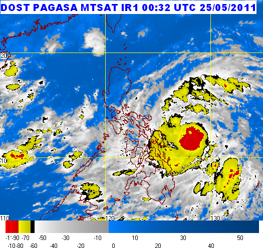
Bagyong Chedeng's May 23, 2011 11 a.m satellite shot | Source PAGASA

Severe Weather Bulletin Number TWO
Tropical Cyclone Alert: Tropical Storm "CHEDENG" (SONGDA)
Issued at 11:00 a.m., Monday, 23 May 2011

Tropical Storm "CHEDENG" has accelerated slightly as it continues to move in a West Northwest direction.

Location of Center (as of 10:00 a.m.): 795 kms East of Guiuan, Eastern Samar

Coordinates: 11.2°N, 133.8°E

Strength: Maximum sustained winds of 95 kph near the center and gustiness of up to 120 kph

Movement: West Northwest at 15 kph

Forecast Positions/Outlook: Tuesday morning: 540 kms East Northeast of Guiuan, Eastern Samar; Wednesday morning: 360 km East Northeast of Virac, Catanduanes; Thursday morning: 265 km North Northeast of Virac, Cantanduanes or 250 km East of Casiguran, Aurora

No Public Storm Warning Signals Raised

This weather disturbance is expected not to directly affect any part of the country within the next 24 hrs.

The public and the disaster coordinating councils concerned are advised to take appropriate actions and watch for the next bulletin to be issued at 11 PM today.


***Weather Update from PAGASA: May 23, 2011, 5 a.m.

Severe Weather Bulletin Number ONE
Tropical Cyclone Alert: Severe Tropical Storm "CHEDENG" (SONGDA)
Issued at 5:00 a.m., Monday, 23 May 2011


The tropical storm East of Northern Mindanao has entered the Philippine Area of Responsibility (PAR) and was named "CHEDENG".

Location of Center(as of 4:00 a.m.): 880 kms East of Guiuan, Eastern Samar

Coordinates: 10.5°N, 134.7°E

Strength: Maximum sustained winds of 95 kph near the center and gustiness of up to 120 kph

Movement: West Northwest at 13 kph

Forecast Positions/Outlook: Tuesday morning:620 kms East of Guiuan, Eastern Samar;
Wednesday morning: 390 km East Northeast of Guiuan, Eastern Samar or
510 km East Southeast of Virac, Catanduanes; Thursday morning: 240 km East Northeast of Virac, Cantanduanes

No Public Storm Warning Signals Raised

This weather disturbance is expected not to directly affect any part of the country within the next 24 hrs.

The public and the disaster coordinating councils concerned are advised to take appropriate actions and watch for the next bulletin to be issued at 11 AM today.


***Weather Update from PAGASA: May 22, 2011, 10:30 a.m.

According to the weather update issued by the Philippine Atmospheric Geophysical and Astronomical Services Administration (PAGASA) at 10:30 a.m. on May 22, "Bagyong Chedeng" (international name "Songda") is 1,070 kilometers away from east of Northern Mindanao and is moving at 11 kph West Northwest.

The typhoon is expected to enter the Philippine Area of Responsibility (PAR) on Sunday night, or if not early morning on Monday.

PAGASA earlier announced that parts of Eastern Visayas will be affected by "Chedeng."

Here is the full text of PAGASA's weather advisory:

Weather Advisory No. 3
For: Tropical Storm (Songda)
Issued at 10:30 a.m., 22 May 2011

At 10:00 am Today, the Tropical Storm (Songda) was estimated based on satellite and surface data at 1,070 km East of Northern Mindanao, (9.7°N, 136.8°E).with maximum sustained winds of 75 kph and gustiness of up to 90 kph. It is forecast to move West Northwest at 11 kph.

This weather disturbance is still outside of the Philippine Area of Responsibility (PAR) and is expected to enter tonight or early tomorrow morning.

The next weather advisory or alert will be issued at 11 am tomorrow or earlier when this weather disturbance enters par.

'Bebeng' kills 15, leaves 3 missing and 2 injured | Latest PAGASA Typhoon Update

"Bebeng", the name given to the most recent tropical storm that hit the Philippines, has left 15 people dead, 3 others missing and 2 were in. This is according to the May 10 report of the National Disaster Risk Reduction and Management Council (NDRRMC).

Satellite image of Bagyong Bebeng captured by the PAGASA on May 10 at 2:32(UTC)

Here are the names of the victims as reported by the NDRRMC:

Dead:

Roberto Hojila, 33
Alberto Tolentino, 59
Rexambard Tayamora, 9
Maricel Reulan, 19
Princess Reulan, 8 months
Marco Sanchez, 7
Aristeo Sabido, 31
Rolandro Balandia
Mario Nuñez, 52
Arnulfo Pesito, 23
Lourdes Lantero, 58
Adrian Clark Ayanan, 16
Jesus Paloma, 45
Luis Dingcol, 46
Jerry Mijares, 38

Missing:

Agmeti Condat, 66
Dodoy Ronan
Mr. Abagat

Injured:

Judy Llantero, 27
Dominador Jamito, 56

Meanwhile, according to the latest PAGASA bulletin on Typhoon "Bebeng" at 11:00 am on May 10, the tropical storm continues to "move away from the country". Only one province remains on the list of areas with public storm warning - Batanes with Signal Number 1.

Typhoon Bebeng, May 9, 2011 PAGASA Update

Typhoon Bebeng has slightly weakened as it moves North Northeastward. This is according to the latest bulletin of the Philippine Atmospheric, Geophysical and Astronomical Services Administraton (PAGASA).

A 13:32 (UTC), May 9, 2011 Satellite Image of Tropical Storm Bebeng courtesy of the PAGASA


Meanwhile check out below the latest "Bebeng" update from PAGASA:


Severe Weather Bulletin Number THIRTEEN
Tropical Cyclone Warning: Tropical Storm "BEBENG" (AERE)
Issued at 11:00 p.m., Monday, 09 May 2011

Location of Center (as of 10:00 a.m.): 85 km Northeast of Aparri, Cagayan

Coordinates: 18.6°N, 122.5°E

Strength: Maximum sustained winds of 65 kph near the center and gustiness of up to 80 kph

Movement:
North Northwest at 15 kph

Forecast Positions/Outlook: Tuesday Evening: 180 km Northeast of Basco, Batanes; Wednesday Evening: 540 km North Northeast of Basco, Batanes or 270 km Southwest of Okinawa, Japan

Areas Having Public Storm Warning Signal

Public Storm Signal No. 2 (60-100 kph winds): Cagayan, Babuyan and Calayan

Public Storm Signal No. 1 (30-60 kph winds): Isabela, Quirino, Ifugao, Mt. Province, Kalinga, Apayao, Batanes

Public Storm Warning Signals elsewhere are now lowered.

Tropical Storm "Bebeng" is expected to bring rains over the western section of Luzon. Residents in low lying areas and near mountain slopes under signal #2 and #1 are advised to take all the necessary precautions against possible flashfloods and landslides. Likewise, those living in coastal areas are alerted against big waves or storm surges generated by this tropical cyclone.

The public and the disaster coordinating councils concerned are advised to take appropriate actions and watch for the next bulletin to be issued at 5 a.m. tomorrow.

PAGASA Weather Forecast: Tropical Storm 'Bebeng' Update

Update: Typhoon Bebeng, May 9, 2011 PAGASA Update

Courtesy of the PAGASA website here's the most recent update on Tropical Storm "Bebeng":

Severe Weather Bulletin Number NINE
Tropical Cyclone Warning: Tropical Storm "BEBENG" (AERE)
Issued at 11:00 p.m., Sunday, 08 May 2011
Tropical Storm "BEBENG" has maintained its strength and threatens Quezon-Aurora.
Location of Center:
(as of 10:00 p.m.)
80 km North Northwest of Daet, Camarines Norte
Coordinates: 14.9°N, 122.6°E
Strength: Maximum sustained winds of 85 kph near the center and gustiness of up to 100 kph
Movement: Northwest at 15 kph
Forecast Positions/Outlook: Monday evening:
60 km East of Vigan City
Tuesday evening:
60 km North of Basco, Batanes
Wednesday evening:
380 km North Northeast of Basco, Batanes


Areas Having Public Storm Warning Signal

Signal No. 2

Camarines Norte
Northern Quezon
Polillo Island
Aurora
Nueva Ecija
Quirino
Nueva Viscaya
Ifugao
Isabela

Signal No. 1

Camarines Sur
Rest of Quezon
Marinduque
Batangas
Cavite
Laguna
Rizal
Bulacan
Bataan
Pampanga
Tarlac
Zambales
Pangasinan
La Union
Benguet
Mt. Province
Ilocos Sur
Kalinga
Cagayan
Metro Manila

Public Storm Warning Signals elsewhere are now lowered.

Tropical Storm Bebeng is expected to enhance the southwest monsoon and bring rains over the rest of Southern Luzon and of Visayas. Residents in low lying areas and near mountain slopes under signal #2 and #1 are advised to take all the necessary precautions against possible flashfloods and landslides. Likewise, those living in coastal areas are alerted against big waves or storm surges generated by this tropical cyclone.

The public and the disaster coordinating councils concerned are advised to take appropriate actions and watch for the next bulletin to be issued at 5 AM tomorrow.

Holy Week Special Weather Outlook from PAGASA

Is it going to be a rainy or sunny Holy Week 2011? Find out.

The Philippine Atmospheric, Geophysical and Astronomical Services Administration (PAGASA) released today a special weather outlook for the Holy Week, April 17-24, 2011.

Here it is:

SPECIAL WEATHER OUTLOOK FOR THE HOLY WEEK
April 17-24, 2011


The easterly wave and low pressure area (LPA) are expected to be the dominant weather systems to affect Visayas and Mindanao. These weather systems will bring scattered rainshowers and thunderstorms throughout outlook period becoming widespread over western Mindanao on Monday and Tuesday (April 18 &19), likewise widespread rains over eastern Visayas and eastern Mindanao on Friday until Sunday (April 22-24). For Luzon, generally good weather condition associated with warm and humid temperature ranging from 24-36 degree Celsius in plain areas and 14-28 degree Celsius over the mountainous region.

The coastal waters throughout the archipelago will be slight to moderate except during thunderstorms.

No tropical cyclone development is expected throughout the outlook period.

This outlook will be updated as soon as significant changes in the weather occur.

For more information, please contact the forecaster-on-duty in the following telephone numbers: 927-2877/927-1541/926-4258.

I hope that could help you plan our activities for this Holy Week out. :D